September 7, 2023
What Lies Beneath?
See What’s Happening Below the Surface of the FM Area Diversion Project
We know to call 811 before digging around our homes, but who do you call when you’re digging down to a depth that would hide a two-story house? A lot of people, it turns out: cultural artifact experts, utility companies, archaeologists and many others.
What We Know
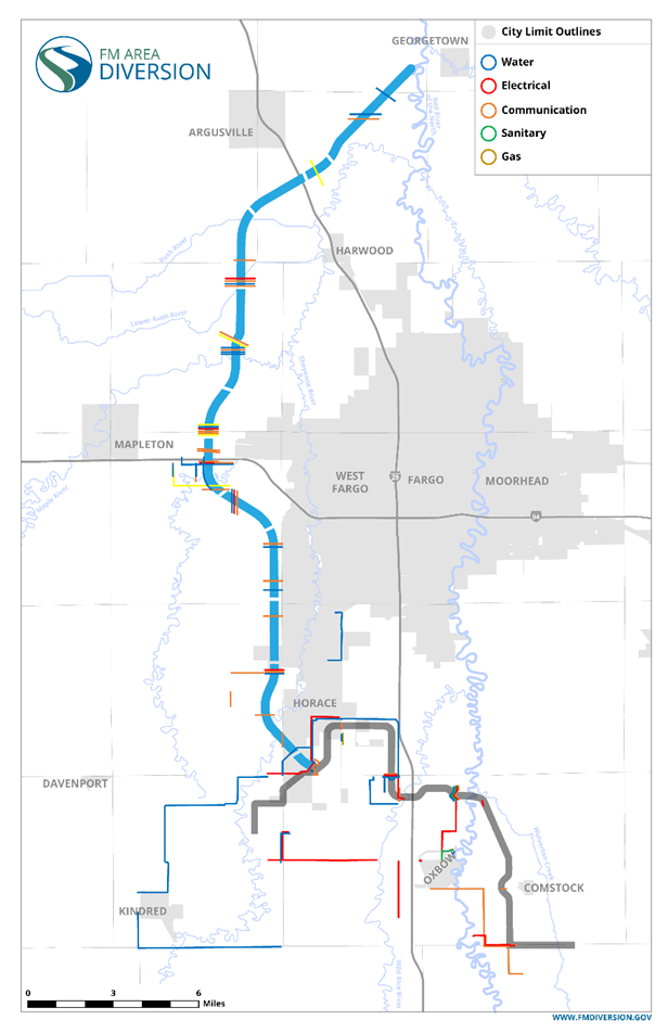
Let’s start with the things we know are underground: utility lines.
Eighteen utility companies have 42 miles of lines running through the area for the stormwater diversion channel. Another 23 companies have lines impacted by the 22-mile southern embankment portion of the project. From AT&T to Xcel Energy, they’re all involved in helping to make permanent flood protection a reality.
The lines range from a mere inch in diameter for some telecommunications lines to as much as a foot across for some water lines. All are getting a new location.
The first company to start work was NuStar Energy, which began relocating a 10-inch, high-pressure petroleum pipeline south of I-94 the summer of 2021. Two years later, most new designs have been completed as well as about 20 percent of the construction work.
The companies have agreements with either the Metro Flood Diversion Authority or U.S. Army Corps of Engineers to not only complete the work but to be reimbursed for making the necessary changes. While doing the work, some companies have chosen to implement additional upgrades at their own expense to benefit customers.
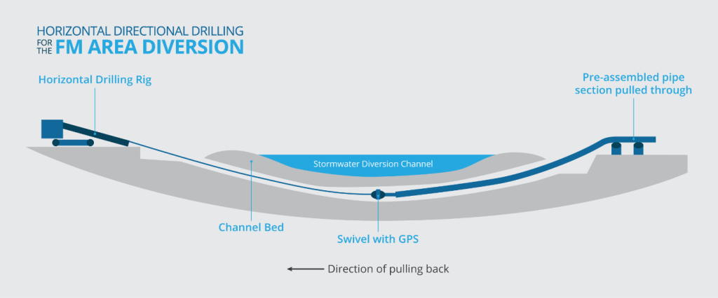
Crews are using horizontal directional drilling, which allows them to tunnel underground and arc the lines under the channel. It’s an established and preferred method for running lines under large rivers, which have similarities to the stormwater diversion channel. The deepest part of the channel drops 25 feet below ground. At ground level, where the channel is widest, it stretches 1,500 feet across.
The utility lines are being routed well below the channel’s base – anywhere from 20 to 75 feet below the low-flow channel, the lowest point. All relocations should be completed within a couple of more years.
What We Don’t Know
Now let’s look at the things that may or may not be under the surface – things that might date back thousands of years. To ensure preservation of any significant archaeological finds that may turn up during excavation, the Metro Flood Diversion Authority connected early on with partners, including State Historical Preservation Offices in North Dakota and Minnesota and the U.S. Army Corps of Engineers.
Those partners helped identify eight sites needing special cultural excavation techniques as well as nine areas where rivers come close to or cross the stormwater diversion channel. Floodplains, oxbows and river terraces not only would have had more activity historically by both animals and humans, but they also have a high potential for deeply buried archaeological finds that can’t be located with standard subsurface testing by archaeologists.
Throughout these 17 identified sites, ASN Constructors uses a smooth blade to excavate in layers, called lifts, that are no more than 10 inches deep, all while a certified North Dakota archaeologist follows the excavator’s path to monitor the work from a safe distance. The archaeologist documents everything found, such as arrowheads, pottery, signs of fire pits, animal bones and teeth, preserved bits of food, pieces of cloth or beads from Native Americans or early pioneer settlers – anything that might provide insight into the historical culture of the area.
If you recall back to geology class, the Holocene layer lies closest to the top of the earth’s surface and covers a period back to roughly 11,700 years ago. Since humans first arrived in North Dakota 12,000 to 13,000 years ago, discoveries would be primarily within that geological horizon, which goes down roughly 16 feet.
If artifacts are found during excavation, construction work stops at that site until archaeologists from the Corps of Engineers can investigate further. They work in accordance with a programmatic agreement that the U.S. Army Corps of Engineers and Metro Flood Diversion Authority signed with the States of North Dakota and Minnesota as well as several tribes. Archaeologists submit each investigation’s results to the State Historical Preservation Offices in North Dakota and Minnesota, and the offices provide direction on how to document and, if needed, preserve, the artifacts.

So, how long until a wooly mammoth or mastodon turn up? While the find would be exciting, it’s not likely. These creatures roamed during the Pleistocene Epoch, which ended more than 13,000 years ago (check out our graphic for a geology refresher!). It’s rare that biological remains from that era would be preserved well enough to be saved if they were found, and finding one is unlikely due to the depth of that layer. Fish, plants or bison are the most likely biological specimens that may turn up.
Excavation started a year ago on the channel, but there are no big finds to report just yet. There has been a mix of modern and historic artifacts documented to date, including stone flakes from making tools, fire-cracked rocks, glass, shells, animal remains, iron, brick, charcoal, plastic bottles, barbwire strands and a partial shellfish hook.
While the opportunity to find something historic still remains, at this point it seems the most valuable thing is the history being made today by building a one-of-a-kind design for permanent, reliable flood protection.